\n$1","comment":{"@type":"Comment","text":"282º \n$1"}},{"@type":"Answer","position":1,"encodingFormat":"text/html","text":"296º \n$1","comment":{"@type":"Comment","text":"296º \n$1"}},{"@type":"Answer","position":2,"encodingFormat":"text/html","text":"301º \n$1","comment":{"@type":"Comment","text":"301º \n$1"}},{"@type":"Answer","position":3,"encodingFormat":"text/html","text":"284º \n$1","comment":{"@type":"Comment","text":"284º \n$1"}}],"acceptedAnswer":[{"@type":"Answer","position":1,"encodingFormat":"text/html","text":"296º \n$1","comment":{"@type":"Comment","text":"To calculate the actual true track, you need to add the planned true track of 283º with the actual drift angle of 7ºR (right) as the drift is towards the right. Therefore, 283º + 7º = 290º. Then, adjust for the easterly variation of 12ºE by subtracting it from the result. So, 290º - 12º = 278º. However, since the variation is east, you need to add it instead. Therefore, 278º + 12º = 290º. Hence, the actual true track is 290º."},"answerExplanation":{"@type":"Comment","text":"To calculate the actual true track, you need to add the planned true track of 283º with the actual drift angle of 7ºR (right) as the drift is towards the right. Therefore, 283º + 7º = 290º. Then, adjust for the easterly variation of 12ºE by subtracting it from the result. So, 290º - 12º = 278º. However, since the variation is east, you need to add it instead. Therefore, 278º + 12º = 290º. Hence, the actual true track is 290º."}}]},{"@type":"Question","eduQuestionType":"Multiple choice","learningResourceType":"Practice problem","name":"Time","text":"On the 15th October, a pilot is departing from Auckland, New Zealand (37°00'S, 174°47'E,position west of the International Date Line; LT = UTC + 12 hours) for a flight to Honolulu inHawaii, U.S. (21°19'N, 157°55'W, position east of the International Date Line; LT = UTC - 10hours).When departing, the aircraft's master clock displays 08:15 UTC.After landing, the pilot records a flight time of 8 hours and 37 minutes.Which of the below statements is correct?","comment":{"@type":"Comment","text":""},"encodingFormat":"text/html","suggestedAnswer":[{"@type":"Answer","position":0,"encodingFormat":"text/html","text":"The aircraft arrives in Honolulu at 16:52 LT on the 15th October. $1","comment":{"@type":"Comment","text":"The aircraft arrives in Honolulu at 16:52 LT on the 15th October. $1"}},{"@type":"Answer","position":1,"encodingFormat":"text/html","text":"When the aircraft arrives in Honolulu, the local date in Auckland is still the 15th October. $1","comment":{"@type":"Comment","text":"When the aircraft arrives in Honolulu, the local date in Auckland is still the 15th October. $1"}},{"@type":"Answer","position":2,"encodingFormat":"text/html","text":"Upon arrival the master clock of the aircraft displays 16:52 UTC and the local date is the 16th October. $1","comment":{"@type":"Comment","text":"Upon arrival the master clock of the aircraft displays 16:52 UTC and the local date is the 16th October. $1"}},{"@type":"Answer","position":3,"encodingFormat":"text/html","text":"The aircraft arrives in Honolulu at 06:52 LT on the 15th October. $1","comment":{"@type":"Comment","text":"The aircraft arrives in Honolulu at 06:52 LT on the 15th October. $1"}}],"acceptedAnswer":[{"@type":"Answer","position":3,"encodingFormat":"text/html","text":"The aircraft arrives in Honolulu at 06:52 LT on the 15th October. $1","comment":{"@type":"Comment","text":"The aircraft arrives in Honolulu at 06:52 LT on the 15th October."},"answerExplanation":{"@type":"Comment","text":"The aircraft arrives in Honolulu at 06:52 LT on the 15th October."}}]},{"@type":"Question","eduQuestionType":"Multiple choice","learningResourceType":"Practice problem","name":"Visual Flight Rule (VFR) Navigation","text":"(See Image). A pilot has planned a flight from aerodrome Strunkovice (LKSR) (N49°05', E014°04') to aerodrome Hohenfels (ETIH) (N49°13', E011°50') using the route shown on the annex. The pilot has been looking out while the aircraft has been drifting to the right of track. NOT looking at the stop watch, he/she mistakes EDNF (N48°50', E013°22') for EDMV (N48°38', E013°12') and turns right for the next leg. Seeing the mast, with elevation 3754 ft (N48°49', E013°13'), there are doubts about the aircraft's position. What is the best option to follow in order to re-establish the aircraft's position? \n ","comment":{"@type":"Comment","text":""},"encodingFormat":"text/html","suggestedAnswer":[{"@type":"Answer","position":0,"encodingFormat":"text/html","text":"Continue on the present heading in order to reach the next waypoint $1","comment":{"@type":"Comment","text":"Continue on the present heading in order to reach the next waypoint $1"}},{"@type":"Answer","position":1,"encodingFormat":"text/html","text":"Circle to establish the aircraft's exact position. $1","comment":{"@type":"Comment","text":"Circle to establish the aircraft's exact position. $1"}},{"@type":"Answer","position":2,"encodingFormat":"text/html","text":"Tune in the RODING (RDG) VOR/DME to confirm the aircraft's position and re-route accordingly. $1","comment":{"@type":"Comment","text":"Tune in the RODING (RDG) VOR/DME to confirm the aircraft's position and re-route accordingly. $1"}},{"@type":"Answer","position":3,"encodingFormat":"text/html","text":"Climb to a higher level, reverse track back to aerodrome Strunkovice, and re-route from there. $1","comment":{"@type":"Comment","text":"Climb to a higher level, reverse track back to aerodrome Strunkovice, and re-route from there. $1"}}],"acceptedAnswer":[{"@type":"Answer","position":2,"encodingFormat":"text/html","text":"Tune in the RODING (RDG) VOR/DME to confirm the aircraft's position and re-route accordingly. $1","comment":{"@type":"Comment","text":"."},"answerExplanation":{"@type":"Comment","text":"."}}]},{"@type":"Question","eduQuestionType":"Multiple choice","learningResourceType":"Practice problem","name":"Charts","text":"Refer to the Annex or to chart E(LO)2 from the Jeppesen GSPRM 2017. Determine the initial track from position A (N54°53', W005°18') to position B (N55°18', W003°35') and also the distance from position A to the point of crossing the meridian of W004°00'. \n ","comment":{"@type":"Comment","text":""},"encodingFormat":"text/html","suggestedAnswer":[{"@type":"Answer","position":0,"encodingFormat":"text/html","text":"Track: 070°(M); Distance: 48 NM $1","comment":{"@type":"Comment","text":"Track: 070°(M); Distance: 48 NM $1"}},{"@type":"Answer","position":1,"encodingFormat":"text/html","text":"Track: 067°(T); Distance: 63 NM $1","comment":{"@type":"Comment","text":"Track: 067°(T); Distance: 63 NM $1"}},{"@type":"Answer","position":2,"encodingFormat":"text/html","text":"Track: 064°(M); Distance: 48 NM $1","comment":{"@type":"Comment","text":"Track: 064°(M); Distance: 48 NM $1"}},{"@type":"Answer","position":3,"encodingFormat":"text/html","text":"Track: 070°(T); Distance: 63 NM $1","comment":{"@type":"Comment","text":"Track: 070°(T); Distance: 63 NM $1"}}],"acceptedAnswer":[{"@type":"Answer","position":0,"encodingFormat":"text/html","text":"Track: 070°(M); Distance: 48 NM $1","comment":{"@type":"Comment","text":"."},"answerExplanation":{"@type":"Comment","text":"."}}]},{"@type":"Question","eduQuestionType":"Multiple choice","learningResourceType":"Practice problem","name":"Great Circles And Rhumb Lines","text":"Given the following information, calculate, to the nearest whole degree, the value of Earth convergence between positions A and B.A: 46°20'N, 005°40'WB: 62°40'N, 013°55'E.","comment":{"@type":"Comment","text":""},"encodingFormat":"text/html","suggestedAnswer":[{"@type":"Answer","position":0,"encodingFormat":"text/html","text":"24° $1","comment":{"@type":"Comment","text":"24° $1"}},{"@type":"Answer","position":1,"encodingFormat":"text/html","text":"11° $1","comment":{"@type":"Comment","text":"11° $1"}},{"@type":"Answer","position":2,"encodingFormat":"text/html","text":"16° $1","comment":{"@type":"Comment","text":"16° $1"}},{"@type":"Answer","position":3,"encodingFormat":"text/html","text":"8° $1","comment":{"@type":"Comment","text":"8° $1"}}],"acceptedAnswer":[{"@type":"Answer","position":2,"encodingFormat":"text/html","text":"16° $1","comment":{"@type":"Comment","text":"Earth convergence is the angle between two meridians at a specific latitude, caused by the Earth's curvature. To calculate it, we find the difference in longitude between the two positions (13°55'E - 5°40'W = 19°35'), then multiply this by the cosine of the mean latitude (54°30'N) to get the convergence of approximately 16°."},"answerExplanation":{"@type":"Comment","text":"Earth convergence is the angle between two meridians at a specific latitude, caused by the Earth's curvature. To calculate it, we find the difference in longitude between the two positions (13°55'E - 5°40'W = 19°35'), then multiply this by the cosine of the mean latitude (54°30'N) to get the convergence of approximately 16°."}}]},{"@type":"Question","eduQuestionType":"Multiple choice","learningResourceType":"Practice problem","name":"Basics of Navigation","text":"The standard parallels of a Lambert’s conical projection are 07°40’N and 38°20’N. For this chart, what is the approximate constant of the cone?","comment":{"@type":"Comment","text":""},"encodingFormat":"text/html","suggestedAnswer":[{"@type":"Answer","position":0,"encodingFormat":"text/html","text":"0.60 $1","comment":{"@type":"Comment","text":"0.60 $1"}},{"@type":"Answer","position":1,"encodingFormat":"text/html","text":"0.39 $1","comment":{"@type":"Comment","text":"0.39 $1"}},{"@type":"Answer","position":2,"encodingFormat":"text/html","text":"0.42 $1","comment":{"@type":"Comment","text":"0.42 $1"}},{"@type":"Answer","position":3,"encodingFormat":"text/html","text":"0.92 $1","comment":{"@type":"Comment","text":"0.92 $1"}}],"acceptedAnswer":[{"@type":"Answer","position":1,"encodingFormat":"text/html","text":"0.39 $1","comment":{"@type":"Comment","text":"The constant of the cone for Lambert's conical projection can be calculated using the formula: Constant = cos(standard parallel)1 + sin(standard parallel)1 * sin(standard parallel)2\nSubstituting the given standard parallels of 07°40’N and 38°20’N, the approximate constant of the cone is 0.39."},"answerExplanation":{"@type":"Comment","text":"The constant of the cone for Lambert's conical projection can be calculated using the formula: Constant = cos(standard parallel)1 + sin(standard parallel)1 * sin(standard parallel)2\nSubstituting the given standard parallels of 07°40’N and 38°20’N, the approximate constant of the cone is 0.39."}}]},{"@type":"Question","eduQuestionType":"Multiple choice","learningResourceType":"Practice problem","name":"Time","text":"While flying on an easterly track and crossing the dateline, the Local Time (LT) will (1)_____ and the date (2)_____.","comment":{"@type":"Comment","text":""},"encodingFormat":"text/html","suggestedAnswer":[{"@type":"Answer","position":0,"encodingFormat":"text/html","text":"(1) Move backward by 12 hours; (2) go back one day. $1","comment":{"@type":"Comment","text":"(1) Move backward by 12 hours; (2) go back one day. $1"}},{"@type":"Answer","position":1,"encodingFormat":"text/html","text":"(1) Stay unchanged; (2) go back one day. $1","comment":{"@type":"Comment","text":"(1) Stay unchanged; (2) go back one day. $1"}},{"@type":"Answer","position":2,"encodingFormat":"text/html","text":"(1) Stay unchanged; (2) go forward by one day. $1","comment":{"@type":"Comment","text":"(1) Stay unchanged; (2) go forward by one day. $1"}},{"@type":"Answer","position":3,"encodingFormat":"text/html","text":"(1) Move forward by 12 hours; (2) go back one day. $1","comment":{"@type":"Comment","text":"(1) Move forward by 12 hours; (2) go back one day. $1"}}],"acceptedAnswer":[{"@type":"Answer","position":1,"encodingFormat":"text/html","text":"(1) Stay unchanged; (2) go back one day. $1","comment":{"@type":"Comment","text":"When flying on an easterly track and crossing the dateline, the Local Time (LT) will stay unchanged and the date will go back one day."},"answerExplanation":{"@type":"Comment","text":"When flying on an easterly track and crossing the dateline, the Local Time (LT) will stay unchanged and the date will go back one day."}}]},{"@type":"Question","eduQuestionType":"Multiple choice","learningResourceType":"Practice problem","name":"Visual Flight Rule (VFR) Navigation","text":"On a topographical chart, contour lines that are very close together indicate that the terrain...","comment":{"@type":"Comment","text":""},"encodingFormat":"text/html","suggestedAnswer":[{"@type":"Answer","position":0,"encodingFormat":"text/html","text":"has a gradual slope. $1","comment":{"@type":"Comment","text":"has a gradual slope. $1"}},{"@type":"Answer","position":1,"encodingFormat":"text/html","text":"is a level plain. $1","comment":{"@type":"Comment","text":"is a level plain. $1"}},{"@type":"Answer","position":2,"encodingFormat":"text/html","text":"is a shallow mountain bowl. $1","comment":{"@type":"Comment","text":"is a shallow mountain bowl. $1"}},{"@type":"Answer","position":3,"encodingFormat":"text/html","text":"is steep. $1","comment":{"@type":"Comment","text":"is steep. $1"}}],"acceptedAnswer":[{"@type":"Answer","position":3,"encodingFormat":"text/html","text":"is steep. $1","comment":{"@type":"Comment","text":"Contour lines that are very close together on a topographical chart indicate that the terrain is steep."},"answerExplanation":{"@type":"Comment","text":"Contour lines that are very close together on a topographical chart indicate that the terrain is steep."}}]},{"@type":"Question","eduQuestionType":"Multiple choice","learningResourceType":"Practice problem","name":"Charts","text":"Refer to chart E(LO)2_02 from Jeppesen GSPRM 2017. Given the following bearing and range information obtained from DEN HELDER (HDR) VOR/DME (52°54´N, 004°46´E), what is the aircraft's position? (Note: Slant range corrections should be ignored)\nRadial: 258°\nRange: 63 NM\n\n ","comment":{"@type":"Comment","text":""},"encodingFormat":"text/html","suggestedAnswer":[{"@type":"Answer","position":0,"encodingFormat":"text/html","text":"52°42´N, 003°04´E $1","comment":{"@type":"Comment","text":"52°42´N, 003°04´E $1"}},{"@type":"Answer","position":1,"encodingFormat":"text/html","text":"52°46´N, 003°42´E $1","comment":{"@type":"Comment","text":"52°46´N, 003°42´E $1"}},{"@type":"Answer","position":2,"encodingFormat":"text/html","text":"53°10´N, 003°03´E $1","comment":{"@type":"Comment","text":"53°10´N, 003°03´E $1"}},{"@type":"Answer","position":3,"encodingFormat":"text/html","text":"52°46´N, 003°48´E $1","comment":{"@type":"Comment","text":"52°46´N, 003°48´E $1"}}],"acceptedAnswer":[{"@type":"Answer","position":0,"encodingFormat":"text/html","text":"52°42´N, 003°04´E $1","comment":{"@type":"Comment","text":"."},"answerExplanation":{"@type":"Comment","text":"."}}]},{"@type":"Question","eduQuestionType":"Multiple choice","learningResourceType":"Practice problem","name":"Great Circles And Rhumb Lines","text":"On a Direct Mercator chart, apart from meridians and the Equator, a great circle will be represented by a…","comment":{"@type":"Comment","text":""},"encodingFormat":"text/html","suggestedAnswer":[{"@type":"Answer","position":0,"encodingFormat":"text/html","text":"complex curve. $1","comment":{"@type":"Comment","text":"complex curve. $1"}},{"@type":"Answer","position":1,"encodingFormat":"text/html","text":"curve convex to the Equator. $1","comment":{"@type":"Comment","text":"curve convex to the Equator. $1"}},{"@type":"Answer","position":2,"encodingFormat":"text/html","text":"straight line. $1","comment":{"@type":"Comment","text":"straight line. $1"}},{"@type":"Answer","position":3,"encodingFormat":"text/html","text":"curve concave to the Equator. $1","comment":{"@type":"Comment","text":"curve concave to the Equator. $1"}}],"acceptedAnswer":[{"@type":"Answer","position":3,"encodingFormat":"text/html","text":"curve concave to the Equator. $1","comment":{"@type":"Comment","text":"On a Direct Mercator chart, apart from meridians and the Equator, a great circle will be represented by a curve concave to the Equator."},"answerExplanation":{"@type":"Comment","text":"On a Direct Mercator chart, apart from meridians and the Equator, a great circle will be represented by a curve concave to the Equator."}}]}]},{"@context":"https://schema.org/","@type":"AggregateRating","itemReviewed":{"@type":"Course","name":"IT Quiz ATPL (H) General Navigation","description":"Quiz ATPL (H) General Navigation - Quiz: 709 domande con spiegazioni e soluzioni, disponibili anche in PDF","provider":{"@type":"Organization","name":"Easy Quizzz","sameAs":"https://www.easy-quizzz.com"},"offers":[{"@type":"Offer","category":"Licenza di Pilota di Linea ATPL Elicottero","priceCurrency":"EUR","price":0}],"about":["Great Circles And Rhumb Lines","Basics of Navigation","Charts","Time","Visual Flight Rule (VFR) Navigation"],"hasCourseInstance":[{"@type":"CourseInstance","courseMode":"Online","courseWorkload":"PT20M"}]},"ratingCount":259,"ratingValue":4.9,"bestRating":5,"worstRating":0}]}
In ogni istante puoi cambiare la modalità di studio, ed alternarti tra la modalità di pratica, e quella di esame. Nella modalità di pratica puoi configurare ad esempio il numero di domande o test, ed altri parametri per aiutarti a studiare.
Domande casuali | 10 Domande per Test | 20 Minuti | 70% per superamento|
Per ri-configurare di nuovo la tua modalità di studio e cambiare - ad esempio - il numero di test, il fatto di avere domande casuali o no e tutte gli altri parametri di configurazione
?Configurazione del simulatore
Auto-scroll: Puoi utilizzare lo scorrimento automatico del questionario che avviene appena rispondi correttamente ad uno o tutte le risposte di una domanda. L'auto scrolling si attiva se rispondi ad una risposta singola, oppure appena rispondi a tutte le risposte obbligatorie. Learning Mode: Durante la modalità di apprendimento puoi ottenere un risultato in tempo reale per la tua risposta.
Prova gratuita
Domanda: / 10
19:59Min. rimanenti
?Riavvia il test corrente
Per ri-iniziare il test corrente azzerando tutte le tue risposte e il tempo fino ad ora utilizzato. Attenzione: tutte le risposte andranno perse.
Domanda: / 10
4.9(259 Voti)
Quiz
Domanda 1/101/10
Basics of Navigation
Given:
Planned true track:
283º
Planned true heading:
289º
Variation:
12ºE
Actual drift angle:
7ºR
Calculate the actual true track...
Seleziona la risposta:Seleziona la risposta
1 risposta corretta
A.
282º
$1
B.
296º
$1
C.
301º
$1
D.
284º
$1
To calculate the actual true track, you need to add the planned true track of 283º with the actual drift angle of 7ºR (right) as the drift is towards the right. Therefore, 283º + 7º = 290º. Then, adjust for the easterly variation of 12ºE by subtracting it from the result. So, 290º - 12º = 278º. However, since the variation is east, you need to add it instead. Therefore, 278º + 12º = 290º. Hence, the actual true track is 290º.
Risposta Corretta: B
Quiz
Domanda 2/102/10
Time
Time
Time
On the 15th October, a pilot is departing from Auckland, New Zealand (37°00'S, 174°47'E,position west of the International Date Line; LT = UTC + 12 hours) for a flight to Honolulu inHawaii, U.S. (21°19'N, 157°55'W, position east of the International Date Line; LT = UTC - 10hours).When departing, the aircraft's master clock displays 08:15 UTC.After landing, the pilot records a flight time of 8 hours and 37 minutes.Which of the below statements is correct?
Seleziona la risposta:Seleziona la risposta
1 risposta corretta
A.
The aircraft arrives in Honolulu at 16:52 LT on the 15th October.
$1
B.
When the aircraft arrives in Honolulu, the local date in Auckland is still the 15th October.
$1
C.
Upon arrival the master clock of the aircraft displays 16:52 UTC and the local date is the 16th October.
$1
D.
The aircraft arrives in Honolulu at 06:52 LT on the 15th October.
$1
The aircraft arrives in Honolulu at 06:52 LT on the 15th October.
Risposta Corretta: D
Quiz
Domanda 3/103/10
Visual Flight Rule (VFR) Navigation
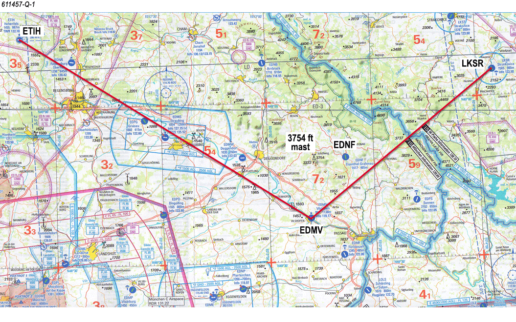
(See Image). A pilot has planned a flight from aerodrome Strunkovice (LKSR) (N49°05', E014°04') to aerodrome Hohenfels (ETIH) (N49°13', E011°50') using the route shown on the annex. The pilot has been looking out while the aircraft has been drifting to the right of track. NOT looking at the stop watch, he/she mistakes EDNF (N48°50', E013°22') for EDMV (N48°38', E013°12') and turns right for the next leg. Seeing the mast, with elevation 3754 ft (N48°49', E013°13'), there are doubts about the aircraft's position. What is the best option to follow in order to re-establish the aircraft's position?
Seleziona la risposta:Seleziona la risposta
1 risposta corretta
A.
Continue on the present heading in order to reach the next waypoint
$1
B.
Circle to establish the aircraft's exact position.
$1
C.
Tune in the RODING (RDG) VOR/DME to confirm the aircraft's position and re-route accordingly.
$1
D.
Climb to a higher level, reverse track back to aerodrome Strunkovice, and re-route from there.
$1
.
Risposta Corretta: C
Quiz
Domanda 4/104/10
Charts
Charts
Charts
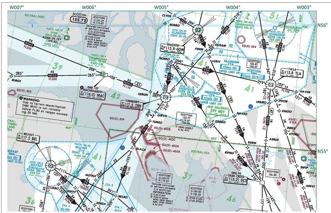
Refer to the Annex or to chart E(LO)2 from the Jeppesen GSPRM 2017. Determine the initial track from position A (N54°53', W005°18') to position B (N55°18', W003°35') and also the distance from position A to the point of crossing the meridian of W004°00'.
Seleziona la risposta:Seleziona la risposta
1 risposta corretta
A.
Track: 070°(M); Distance: 48 NM
$1
B.
Track: 067°(T); Distance: 63 NM
$1
C.
Track: 064°(M); Distance: 48 NM
$1
D.
Track: 070°(T); Distance: 63 NM
$1
.
Risposta Corretta: A
Quiz
Domanda 5/105/10
Great Circles And Rhumb Lines
Given the following information, calculate, to the nearest whole degree, the value of Earth convergence between positions A and B.A: 46°20'N, 005°40'WB: 62°40'N, 013°55'E.
Seleziona la risposta:Seleziona la risposta
1 risposta corretta
A.
24°
$1
B.
11°
$1
C.
16°
$1
D.
8°
$1
Earth convergence is the angle between two meridians at a specific latitude, caused by the Earth's curvature. To calculate it, we find the difference in longitude between the two positions (13°55'E - 5°40'W = 19°35'), then multiply this by the cosine of the mean latitude (54°30'N) to get the convergence of approximately 16°.
Risposta Corretta: C
Quiz
Domanda 6/106/10
Basics of Navigation
The standard parallels of a Lambert’s conical projection are 07°40’N and 38°20’N. For this chart, what is the approximate constant of the cone?
Seleziona la risposta:Seleziona la risposta
1 risposta corretta
A.
0.60
$1
B.
0.39
$1
C.
0.42
$1
D.
0.92
$1
The constant of the cone for Lambert's conical projection can be calculated using the formula:
Constant = cos(standard parallel)1 + sin(standard parallel)1 * sin(standard parallel)2
Substituting the given standard parallels of 07°40’N and 38°20’N, the approximate constant of the cone is 0.39.
Risposta Corretta: B
Quiz
Domanda 7/107/10
Time
Time
Time
While flying on an easterly track and crossing the dateline, the Local Time (LT) will (1)_____ and the date (2)_____.
Seleziona la risposta:Seleziona la risposta
1 risposta corretta
A.
(1) Move backward by 12 hours; (2) go back one day.
$1
B.
(1) Stay unchanged; (2) go back one day.
$1
C.
(1) Stay unchanged; (2) go forward by one day.
$1
D.
(1) Move forward by 12 hours; (2) go back one day.
$1
When flying on an easterly track and crossing the dateline, the Local Time (LT) will stay unchanged and the date will go back one day.
Risposta Corretta: B
Quiz
Domanda 8/108/10
Visual Flight Rule (VFR) Navigation
On a topographical chart, contour lines that are very close together indicate that the terrain...
Seleziona la risposta:Seleziona la risposta
1 risposta corretta
A.
has a gradual slope.
$1
B.
is a level plain.
$1
C.
is a shallow mountain bowl.
$1
D.
is steep.
$1
Contour lines that are very close together on a topographical chart indicate that the terrain is steep.
Risposta Corretta: D
Quiz
Domanda 9/109/10
Charts
Charts
Charts
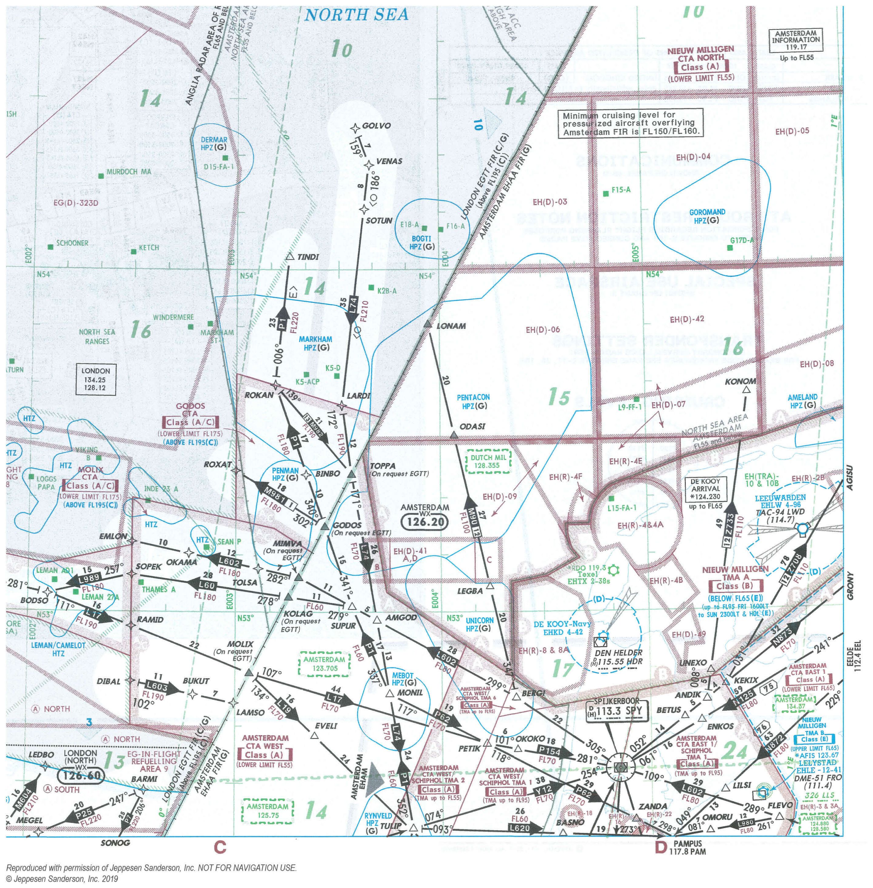
Refer to chart E(LO)2_02 from Jeppesen GSPRM 2017.
Given the following bearing and range information obtained from DEN HELDER (HDR) VOR/DME (52°54´N, 004°46´E), what is the aircraft's position? (Note: Slant range corrections should be ignored)
Radial: 258°
Range: 63 NM
Seleziona la risposta:Seleziona la risposta
1 risposta corretta
A.
52°42´N, 003°04´E
$1
B.
52°46´N, 003°42´E
$1
C.
53°10´N, 003°03´E
$1
D.
52°46´N, 003°48´E
$1
.
Risposta Corretta: A
Quiz
Domanda 10/1010/10
Great Circles And Rhumb Lines
On a Direct Mercator chart, apart from meridians and the Equator, a great circle will be represented by a…
Seleziona la risposta:Seleziona la risposta
1 risposta corretta
A.
complex curve.
$1
B.
curve convex to the Equator.
$1
C.
straight line.
$1
D.
curve concave to the Equator.
$1
On a Direct Mercator chart, apart from meridians and the Equator, a great circle will be represented by a curve concave to the Equator.
Quiz e Simulatore: Quiz ATPL (H) General Navigation - sblocca tutte le domande del simulatore online
Grazie per aver scelto la versione free del Quiz Quiz ATPL (H) General Navigation! Approfondisci ulteriormente le tue conoscenze con i nostri Simulatori Licenza di Pilota di Linea ATPL Elicottero; Sbloccando la versione completa del nostro Simulatore Quiz ATPL (H) General Navigation potrai effettuare test e quiz con oltre 709 domande sempre aggiornate e superare facilmente la tua prove d’esame. Il 98% di persone che si sono esercitate con le nostre 709 domande hanno superato l'esame al primo tentativo.
Cosa aspettarsi dal nostro Simulatore Quiz ATPL (H) General Navigation e come prepararsi a qualsiasi quiz Quiz ATPL (H) General Navigation?
I Test pratici di Quiz ATPL (H) General Navigation fanno parte della Banca Dati Licenza di Pilota di Linea ATPL Elicottero e rappresentano il modo migliore per prepararsi a qualsiasi esame per Quiz ATPL (H) General Navigation. I quiz sono composti da 709 domande divise per 5 argomenti e sono scritti da esperti per aiutarvi e prepararvi a raggiungere l’obiettivo di superare l’esame al primo tentativo. La banca dati per Quiz ATPL (H) General Navigation include domande apparse in esami precedenti e non solo, il che significa che sarete in grado di esercitarvi simulando le domande passate e future. La preparazione al Test Quiz ATPL (H) General Navigation vi offrirà anche un’idea del tempo necessario per completare ogni sezione del Quiz Quiz ATPL (H) General Navigation. È importante notare che il Simulatore Quiz ATPL (H) General Navigation non sostituisce le classiche guide Quiz ATPL (H) General Navigation di studio; tuttavia, il Simulatore fornisce indicazioni preziose su cosa aspettarsi e su quanto lavoro occorra fare per prepararsi all'esame Quiz ATPL (H) General Navigation.
I Quiz Quiz ATPL (H) General Navigation rappresentano quindi un ottimo strumento per prepararsi all’esame vero e proprio assieme ai nostri Quiz Licenza di Pilota di Linea ATPL Elicottero. I nostri test ti aiuteranno a valutare il tuo livello di preparazione e a comprendere i tuoi punti di forza e debolezza. Di seguito potrai leggere tutti i quiz che troverai nel nostro Simulatore Quiz ATPL (H) General Navigation e come è composta la nostra unica Banca Dati Quiz ATPL (H) General Navigation fatta di domande vere e reali:
Info quiz:
Nome del quiz:Quiz ATPL (H) General Navigation
Numero totale di domande:709
Numero di domande per il test:100
Punteggio di superamento:70%
Numero di argomenti:5 argomenti
Argomenti di studio:Numero di domande:
Basics of Navigation:434 domande
Charts:103 domande
Great Circles And Rhumb Lines:63 domande
Time:49 domande
Visual Flight Rule (VFR) Navigation:60 domande
Potete prepararvi agli esami Quiz ATPL (H) General Navigation anche con la nostra applicazione mobile. È molto facile da usare e funziona anche off-line in caso di mancata disponibilità di rete, con tutte le funzioni necessarie per studiare ed esercitarvi con la nostra Banca Dati Quiz ATPL (H) General Navigation.
Utilizzate la nostra Applicazione Mobile, disponibile sia per Android che per iOS, con il nostro Simulatore Quiz ATPL (H) General Navigation. Potete utilizzarla ovunque e ricordate sempre che la nostra applicazione mobile è gratuita e disponibile su tutti gli Store.
L’applicazione mobile contiene tutte i Quiz Quiz ATPL (H) General Navigation per un totale di 709 domande divisi per 5 argomenti e fornirà il materiale di studio per superare l’esame finale con un successo garantito.
Le nostre Banche Dati Quiz ATPL (H) General Navigation contengono centinaia di domande relative all'Esame Quiz ATPL (H) General Navigation e ai Test Licenza di Pilota di Linea ATPL Elicottero. In questo modo sarà possibile esercitarsi quando e dove volete anche in modalità offline.